
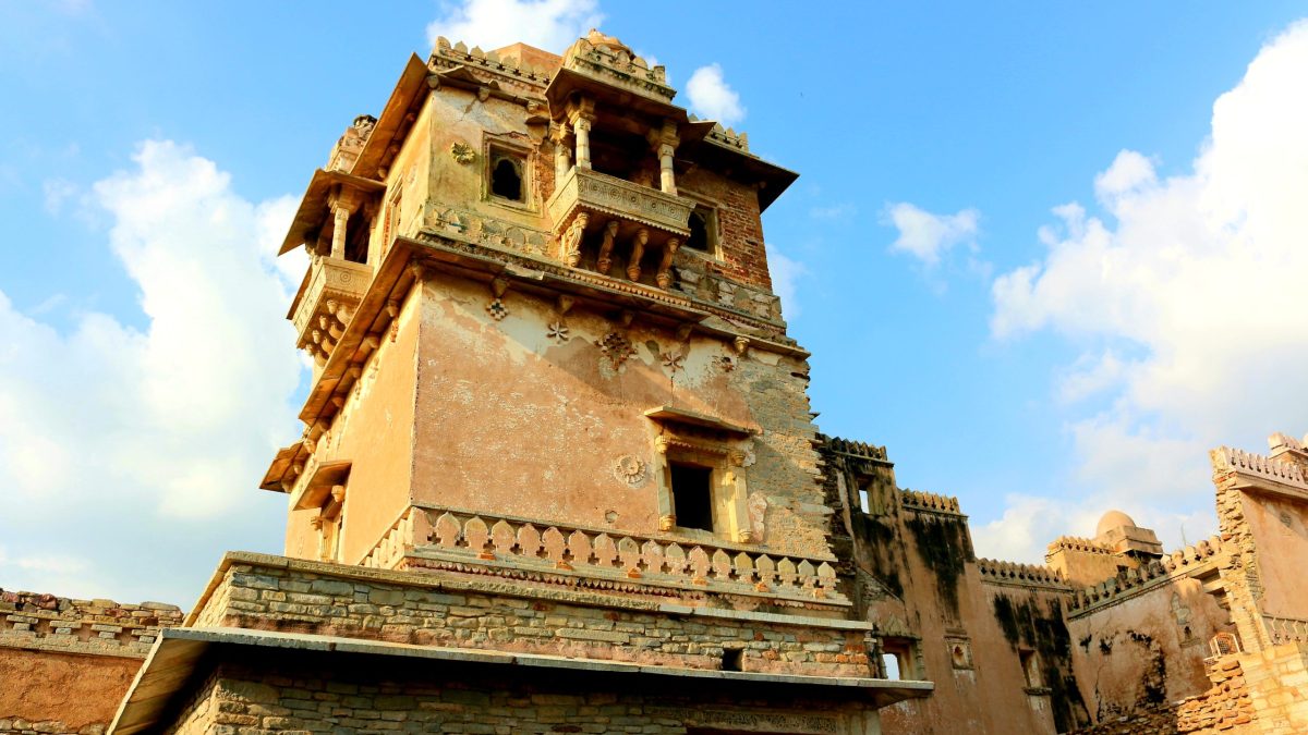
Chittorgarh Fort, also called Chittor Fort, is one of the largest forts in India and a UNESCO World Heritage Site. It was the capital of Mewar and stands on a hill 180 metres high, covering 280 hectares above the plains of the Berach River valley. The fort contains 65 historic structures, including four palaces, 19 large temples, 20 large water bodies, four memorials and a few victory towers.
The origin is told in legend. The fort was originally called Chitrakut and is said to have been built by the Mori ruler Chitrangada Mori, from whom one legend derives its name. Several small Buddhist stupas dated to the 9th century were found at the edge of the Jaimal Patta lake. The Guhila ruler Bappa Rawal is said to have captured the fort in 728 or 734, though some historians doubt that the Guhilas controlled it before the later ruler Allata. The earliest Guhila inscription found at Chittor dates from the reign of Tejasimha in the mid-13th century.
In 1303 Alauddin Khalji of the Delhi Sultanate besieged Chittor, then ruled by the Guhila king Ratnasimha, and took it after an eight-month siege. According to his courtier Amir Khusrow he ordered the massacre of 30,000 local Hindus after the conquest. Later legends say Alauddin invaded to capture Ratnasimha’s queen Padmini, but most modern historians reject those legends. His son Khizr Khan held the fort until 1311, when Rajput pressure forced him to hand it to the Sonigra chief Maldeva. Hammir Singh later took control, and by his death in 1378 he had made Mewar a large and prosperous kingdom. His dynasty came to be known as the Sisodias.
Mewar rose again in the 15th century under Rana Kumbha, who ruled from 1433 to 1468. He is credited with building 32 forts, among them Kumbhalgarh, which formed part of the 84 forts that defended Mewar. Under Rana Sanga, who took the throne in 1509, Mewar reached the peak of its power and ruled from the Sutlej in the north to the Narmada in the south. After he was defeated by Babur and carried unconscious from the field, he took an oath not to return to Chittorgarh until he had beaten Babur and conquered Delhi, and he died in January 1528, reportedly poisoned by his own nobles who did not want another battle.
The decline came with artillery. The fort was deserted as a capital after 1568, when the capital moved to Udaipur, on the east side of the Aravallis, where heavy artillery and cavalry were less effective, and the Mughal emperor Akbar attacked and sacked the fort. A new town, known as the Lower Town, developed in the plains.
The layout reflects its defensive purpose. A winding hill road more than a kilometre long leads from the town to the main western gate, the Ram Pol, and a circular road inside gives access to all the gates and monuments within the walls. Water was crucial: the fort once had 84 water bodies and now has 22, fed by natural catchment and rain, with a combined storage of 4 billion litres, enough to meet the needs of an army of 50,000 for four years. They take the form of ponds, wells and stepwells.
In 2013 the World Heritage Committee, meeting in Phnom Penh, declared the group of six Hill Forts of Rajasthan, including Chittor, a World Heritage Site. The city of Chittorgarh lies in southern Rajasthan, 233 kilometres from Ajmer, midway between Delhi and Mumbai on National Highway 48.
The fort’s history is also one of memory. Accounts of the 1303 siege have been shaped by later legends about Padmini, which historians treat with caution, and the story of its rulers is told through inscriptions, chronicles and legend that do not always agree.
What the structure shows is a capital designed around a hill, with water storage, a single winding approach and layers of palaces and temples added over nine centuries, until the rise of cannon made the hill less safe than the plains beyond the Aravallis.
Featured image: A view of Chittor Fort in Chittorgarh, Rajasthan (file photo). Photo by Rupeshsarkar, licensed under CC BY-SA 4.0, via Wikimedia Commons.

Leave a Reply