
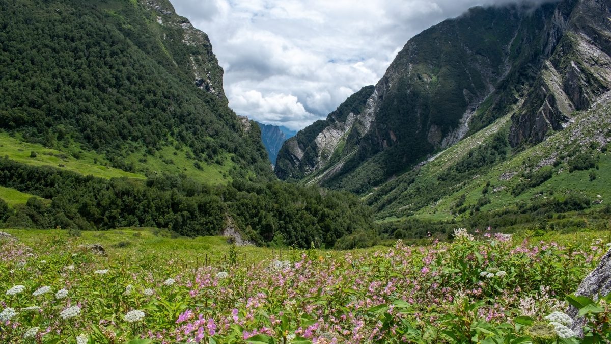
High in the Garhwal Himalaya of Uttarakhand are two national parks of very different character: the stern ring of peaks around Nanda Devi, and, a few valleys away, a gentle meadow that turns into a carpet of flowers every monsoon. Together they form one World Heritage Site.
At a glance
- Location: Chamoli district, Uttarakhand
- Inscribed: 1988 (Nanda Devi); extended in 2005 to include the Valley of Flowers
- Type: Natural
- Highest point: Nanda Devi, 7,816 metres
Nanda Devi
Nanda Devi is the second-highest mountain in India and the highest lying wholly within the country. It is worshipped as a goddess, the patron of Garhwal and Kumaon.
The mountain stands inside a natural fortress: a ring of peaks more than 6,000 metres high, about 110 kilometres round, broken only by the deep gorge of the Rishi Ganga. For fifty years explorers failed to find a way in. The English mountaineers Eric Shipton and Bill Tilman forced the gorge in 1934, and Tilman and Noel Odell climbed the peak in 1936.
The basin within, the Nanda Devi Sanctuary, has glaciers, alpine meadows and herds of blue sheep. Heavy use by expeditions damaged it, and in 1983 it was closed to all visitors. It remains closed, apart from a limited trek in the outer area.
Valley of Flowers
In 1931 the mountaineer Frank Smythe, returning from the peak of Kamet, lost his way in the rain and came down into a valley full of flowers. He came back to botanise and wrote a book about it, which gave the valley its name. Local people had long known it as a grazing ground.
- Size: about 87 square kilometres, the valley floor at around 3,500 metres
- Flowers: more than 500 species of plants, among them the blue poppy, the cobra lily, primulas, anemones, and the brahma kamal, the state flower of Uttarakhand
- Season: the snow melts in June; the bloom is at its best from mid-July to mid-August
Wildlife
Snow leopards, Himalayan black and brown bears, musk deer, blue sheep and the Himalayan monal pheasant live in the two parks.
Why it is a World Heritage Site
The parks are recognised for their exceptional natural beauty and for protecting a range of high-altitude habitats and rare species between the Zanskar and Great Himalaya ranges.
Visiting
The Valley of Flowers is reached on foot. From Govindghat, on the road to Badrinath, a trek of about 14 kilometres leads to the village of Ghangaria, and the valley is a few kilometres beyond. Camping in the valley is not allowed. The Sikh shrine of Hemkund Sahib is reached from the same village. The valley is open from June to early October. The district was also the centre of the Chipko movement to protect Himalayan forests.
Image: Flowers in bloom in the Valley of Flowers National Park, Uttarakhand. Photo by Rohit Sharma (Wikimedia Commons contributor), licensed under CC BY-SA 4.0, via Wikimedia Commons.


Leave a Reply